
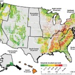
Researchers mapped the invasion-intensity for FIA sample sites and then estimated invasion-intensity for U.S. regions. Image by U.S. Forest Service.
“Many user-friendly resources are available to help landowners. Rapid response and steps to eradicate unwanted introductions are easier in the long run than having to manage the complex consequences of invasive plants.”
“Eastern forests have higher invasion-intensity — that is, a higher percentage of FIA sample sites containing invasive plants of concern in the region or individual states within — than western forests (46 percent vs. 11 percent). Hawaii’s forests have the highest invasion-intensity (70 percent), while forests in Alaska (6 percent) and the Intermountain region (6 percent) have the lowest invasion-intensity”
Read the full article and access resources http://www.srs.fs.usda.gov/compass/2016/01/05/a-big-picture-view-of-the-invasive-plant-problem/
A Big-Picture View of the Invasive Plant Problem by Sarah Workman and Stephanie Worley Firley. Posted on January 5, 2016 by Zoe Hoyle